Post by : Amit
Photo : X / Indian Infra Report
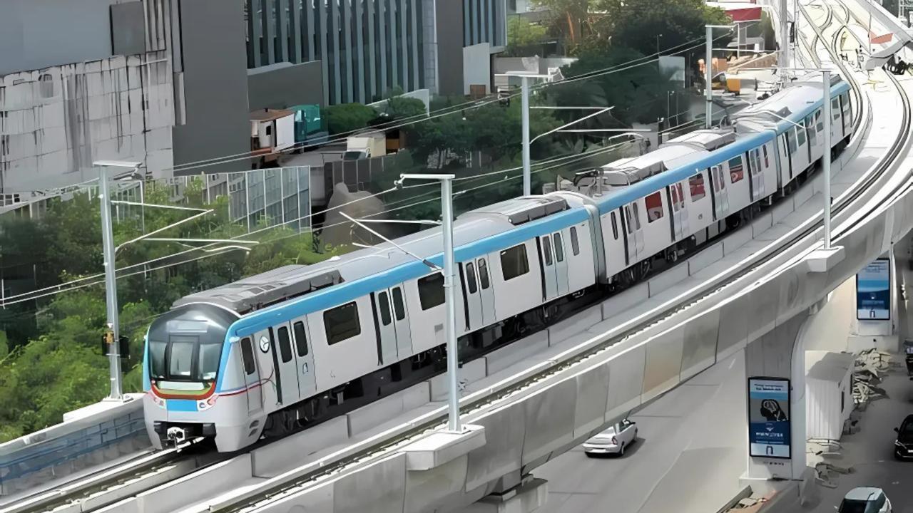
Hyderabad Metro Phase 2: Utility Mapping Sets the Stage for Smarter Urban Expansion
In a city as bustling, fast-growing, and infrastructure-heavy as Hyderabad, every square foot of land—especially below the surface—carries layers of history, utilities, and life-supporting systems. Recognizing the high stakes involved, Hyderabad Metro Rail Limited (HMRL), in partnership with the Telangana government, has embarked on a massive utility mapping exercise as a crucial precursor to the much-anticipated Phase 2 of the Hyderabad Metro Rail project. This step, while seemingly routine, is an engineering and urban planning necessity, setting the foundation for a smart, disruption-free construction strategy.
The Phase 2 expansion will add about 31 kilometers of new metro lines, linking key city corridors that remain underserved. Among these, the BHEL to Lakdikapul stretch is considered vital to reduce vehicular load and offer seamless transit to residents and professionals commuting from industrial and tech-heavy zones.
But before any ground can be broken or tunneling begun, engineers must be certain about what lies beneath the streets—water lines, gas pipes, telecom cables, sewage channels, and electricity wires. That’s where utility mapping steps in.
Why Utility Mapping is a Make-or-Break Element in Metro Construction
In metro infrastructure, utility mapping is the silent groundwork that determines how efficiently, safely, and timely the above-ground marvels are built. The process uses advanced surveying tools like Ground Penetrating Radar (GPR), LiDAR, GPS-based systems, Total Station equipment, and Geographic Information System (GIS) software to generate high-resolution underground maps.
These maps will help metro engineers visualize the subterranean maze, identify potential conflict points, and create a detailed relocation or protection plan. Without this data, construction could hit unplanned snags—burst pipelines, power outages, road sinkholes, or worse, legal liability due to damage caused to third-party infrastructure.
Phase 1 of the Hyderabad Metro, though largely successful, did face challenges arising from unmapped or misidentified utilities. Learning from that experience, officials this time are keen on leaving no pipe or cable undocumented.
Mapping the Path to a Smarter Phase 2
The newly proposed Phase 2 corridors will pass through some of Hyderabad’s busiest and oldest neighborhoods. Areas like Jubilee Hills, Mehdipatnam, Khairatabad, and BHEL are not only densely populated but have evolved urban utility layouts built over decades. Many installations in these areas date back to the early 1980s and 1990s—often poorly documented, with overlapping responsibilities between various civic agencies.
In such contexts, modern mapping techniques are vital. Teams working on the project are using GPR mounted on vehicles that can scan up to 10 meters below the surface. LiDAR-based scanning, done via drones or handheld units, is also being employed to create digital twins of the utility zones.
Each identified utility is geo-tagged and layered into 3D models. Engineers and contractors can now simulate construction plans in a virtual environment, tweak alignments, and finalize relocation schedules—before a single shovel hits the dirt.
Coordination : Agencies Must Talk to One Another
What makes utility mapping truly effective isn’t just the technology—it’s the cooperation between various utility providers and civic bodies. In Hyderabad’s case, agencies involved include:
Without open data sharing, consolidated blueprints, and centralized approvals, utility mapping loses its edge. To tackle this, the state government has activated Hyderabad Unified Metropolitan Transport Authority (HUMTA) to act as a coordination hub. HUMTA’s mandate is to prevent data silos and ensure real-time updates between departments.
A senior HMRL engineer explained, “We’re not just mapping. We’re building a single source of truth for everything that’s underground. That’s the foundation for predictable, safe, and modern urban development.”
Timeline and Funding of Phase 2
The utility mapping project is slated to be completed within 3 to 4 months, depending on weather conditions and clearance timelines. Once this data is finalized, final alignment drawings will be locked in and used for Detailed Project Reports (DPRs). The DPR for Phase 2 has already been submitted to the Central Government for funding and approvals.
The entire Phase 2 expansion is expected to cost ₹8,500 crore. The Telangana state government is optimistic that given the Union Government’s push for green urban mobility and its Smart Cities mission, funding will not be a major hurdle. Parallel efforts are also underway to explore Public-Private Partnership (PPP) models, similar to Phase 1’s financial structure with L&T Metro Rail (Hyderabad) Limited.
The target is to begin civil works in early 2026 and complete key corridors by 2029.
International Standards and Local Execution
India’s metro systems have come a long way in adopting global best practices. Delhi Metro, Bengaluru Metro, and Mumbai Metro have all integrated high-fidelity mapping and GIS-based planning into their latest expansions.
Hyderabad is following suit, bringing in consultants with international experience. Additionally, remote-sensing drones, AI-based mapping software, and conflict detection systems are being deployed to identify overlapping utilities, invisible hazards, and undocumented pipelines.
These steps will not only ensure smoother construction but also cut costs, reduce chances of civic damage, and maintain public confidence throughout the project’s execution phase.
Public Sentiment and the Need for Last-Mile Connectivity
Citizens across Hyderabad have been vocal about the need for metro access in areas currently choked with traffic. Professionals working in tech hubs like Gachibowli, Kondapur, and Financial District have long complained about poor public transport and traffic snarls that stretch commutes to two hours daily.
The proposed Phase 2 corridor aims to bridge these last-mile gaps. Once complete, the Metro will connect economically vibrant regions with affordable, air-conditioned, and eco-friendly mass transport.
Rukmini, a school teacher from Jubilee Hills, said, “The Metro will change how we live. If it comes on time and without digging up roads repeatedly, that’s the dream.”
Engineers and Planners Weigh In
S. Mahesh, an urban mobility consultant involved in several metro projects across South India, said, “Utility mapping is the hidden hero. You won’t see the results immediately, but it decides whether a metro is built on schedule or not.”
Likewise, a retired GHMC engineer who worked on Phase 1 shared: “We once hit a major water line near Ameerpet because we didn’t know it was there. It flooded the site and delayed work by three weeks. This time, no one wants to make that mistake again.”
Building the Invisible Before the Visible
Hyderabad Metro Phase 2 is more than just steel tracks and concrete pillars. It’s a test of modern urban planning, inter-departmental coordination, and technological foresight. The utility mapping exercise now underway is a sign that Hyderabad is planning for its future not just ambitiously, but smartly and responsibly.
With the support of advanced tools, global consultants, and a proactive state government, Phase 2 is on course to become a model for metro expansions in other Tier-1 and Tier-2 cities across India.
The real infrastructure lies beneath. And by mapping it with precision, Hyderabad is laying the groundwork—literally and figuratively—for a safer, faster, and more connected tomorrow.
Hyderabad, Metro, Utility Mapping



Advances in Aerospace Technology and Commercial Aviation Recovery
Insights into breakthrough aerospace technologies and commercial aviation’s recovery amid 2025 chall

Defense Modernization and Strategic Spending Trends
Explore key trends in global defense modernization and strategic military spending shaping 2025 secu

Tens of Thousands Protest in Serbia on Anniversary of Deadly Roof Collapse
Tens of thousands in Novi Sad mark a year since a deadly station roof collapse that killed 16, prote

Canada PM Carney Apologizes to Trump Over Controversial Reagan Anti-Tariff Ad
Canadian PM Mark Carney apologized to President Trump over an Ontario anti-tariff ad quoting Reagan,

The ad that stirred a hornets nest, and made Canadian PM Carney say sorry to Trump
Canadian PM Mark Carney apologizes to US President Trump after a tariff-related ad causes diplomatic
Bengaluru-Mumbai Superfast Train Approved After 30-Year Wait
Railways approves new superfast train connecting Bengaluru and Mumbai, ending a 30-year demand, easi